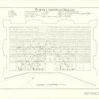
Plan de la Nouvelle Orleans
Dublin Core
Title
Plan de la Nouvelle Orleans
Subject
A plan for the layout of the city of New Orleans
Description
Relief shown pictorially. Cadastral map. Shows block numbers and location of existing buildings. Pen-and-ink. Mounted on cloth backing. Oriented with northwest at top. Copy annotated in pencil at bottom: 142566. Accompanied by: A list of residents keyed by letter and number in pocket. Xerox, 36 leaves. Available also through the Library of Congress Web site as a raster image. Includes list of points of interest. LC Luso-Hispanic world, 960
Creator
Adrien de Pauger and Le
Blond de la Tour
Blond de la Tour
Source
Cornell University Map Collection
Date
c.1722
Citation
Adrien de Pauger and Le
Blond de la Tour, “Plan de la Nouvelle Orleans,” Early American History in Maps, accessed September 27, 2024, https://cornellcolab.net/EarlyAmericanMaps/items/show/123.
