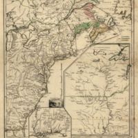
Canada et Louisiane
Dublin Core
Title
Canada et Louisiane
Subject
A map of the French territory in Canada and Louisiana
Description
Scale ca. 1:4,450,000. Hand colored. Relief shown pictorially. Lowery, 415 LC Maps of North America, 1750-1789, 34 Includes illus. of Niagara Falls and additional place-names. Available also through the Library of Congress Web site as a raster image. Vault AACR2: 100; 651/1; 651/2; 651/3
Creator
Georges-Louis le Rouge
Source
Library of Congress
Date
1755
Citation
Georges-Louis le Rouge, “Canada et Louisiane,” Early American History in Maps, accessed September 27, 2024, https://cornellcolab.net/EarlyAmericanMaps/items/show/124.
