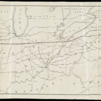
Map of the Clinton Line Railroad and its Connections
Dublin Core
Title
Map of the Clinton Line Railroad and its Connections
Subject
Clinton Line Railroad Company
Railroads
Railroads
Creator
Klauprech & Menzel
Publisher
Cincinnati : Klauprech & Menzel
Boston Public Library
Boston Public Library
Date
[1850–1859]
Type
Map
Still Image Item Type Metadata
Physical Dimensions
51 x 157 cm
Collection
Citation
Klauprech & Menzel, “Map of the Clinton Line Railroad and its Connections,” Early American History in Maps, accessed September 25, 2024, https://cornellcolab.net/EarlyAmericanMaps/items/show/169.
