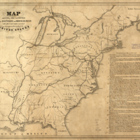
Map shewing the connection of the Baltimore and Ohio-Rail-Road with other rail roads executed or in progress throughout the United States.
Dublin Core
Title
Map shewing the connection of the Baltimore and Ohio-Rail-Road with other rail roads executed or in progress throughout the United States.
Subject
- Baltimore and Ohio Railroad Company--Maps
- Railroads--United States--Maps
- United States
- Railroads--United States--Maps
- United States
Description
Map of the United States east of the Mississippi River. [From published bibliography]
Source
Library of Congress
Publisher
Balt[im]o[re] Lith. of Ed. Weber & Co. [184-?]
Date
[184-?]
Contributor
Edward Weber & Co.
Format
map 46 x 54 cm.
Collection
Citation
“Map shewing the connection of the Baltimore and Ohio-Rail-Road with other rail roads executed or in progress throughout the United States.,” Early American History in Maps, accessed September 26, 2024, https://cornellcolab.net/EarlyAmericanMaps/items/show/226.
