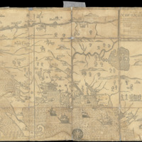
A Map of New-England, being the first that ever was here cut, and done by the best pattern that could be had, which being in some places defective, it made the other less exact yet doth it sufficiently shew the scituation of the Country, and conveniently well the distance of Places. The figures that are joyned with the Names of Places are to distinguish such as have been assaulted by the Indians from others.
Dublin Core
Title
A Map of New-England, being the first that ever was here cut, and done by the best pattern that could be had, which being in some places defective, it made the other less exact yet doth it sufficiently shew the scituation of the Country, and conveniently well the distance of Places. The figures that are joyned with the Names of Places are to distinguish such as have been assaulted by the Indians from others.
Creator
John Foster, William Hubbad
Source
Osher Map Library
https://oshermaps.org/browse-maps?id=46674
https://oshermaps.org/browse-maps?id=46674
Date
1677
Format
Map
Language
English
Coverage
New England, New Hampshire, Massachusetts, Boston, Portsmouth
Collection
Citation
John Foster, William Hubbad , “A Map of New-England, being the first that ever was here cut, and done by the best pattern that could be had, which being in some places defective, it made the other less exact yet doth it sufficiently shew the scituation of the Country, and conveniently well the distance of Places. The figures that are joyned with the Names of Places are to distinguish such as have been assaulted by the Indians from others.,” Early American History in Maps, accessed September 27, 2024, https://cornellcolab.net/EarlyAmericanMaps/items/show/242.
