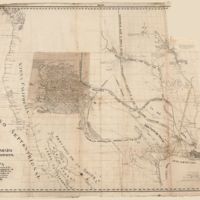
Pichardo 1811 Map
Dublin Core
Title
Pichardo 1811 Map
Description
Relief shown pictorially and by hachures.
- Spanish manuscript map of Spanish Texas, Louisiana Territory and the Trans-Mississippi West, prepared for the use by the Spanish Crown in defending its claims to Spanish Texas against the United States' post-Louisiana Purchase of the lands between the Mississippi River and the Rio Grande.
- Shows four proposed boundary lines, in red and in another color of ink, between New Spain and the United States, drawn by Pichardo, Spanish place names and features, settlements, missions, names of explorers and tracks of their routes.
- Imperfect: Missing upper right portion of sheet and some torn at fold lines.
Source
Library of Congress : https://www.loc.gov/item/2016588016/
Collection
Citation
“Pichardo 1811 Map,” Early American History in Maps, accessed September 27, 2024, https://cornellcolab.net/EarlyAmericanMaps/items/show/62.
