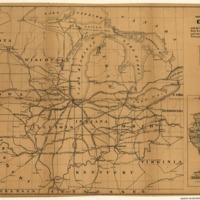
Map showing the position of Chicago in connection with the North West & the principal lines of rail roads, canals, navigable streams and lakes, together with the most important towns, and their distances from Chicago.
Dublin Core
Title
Map showing the position of Chicago in connection with the North West & the principal lines of rail roads, canals, navigable streams and lakes, together with the most important towns, and their distances from Chicago.
Subject
- Railroads--Middle West--Maps
- United States--Middle West
- United States--Middle West
Description
Map of the north-central United States, east of the Mississippi River, showing the railroad network.
Creator
Mendel, Edward, 1827-1884.
Source
Library of Congress
Publisher
Chicago, [185-]
Date
185?
Format
map 43 x 64 cm.
Collection
Citation
Mendel, Edward, 1827-1884. , “Map showing the position of Chicago in connection with the North West & the principal lines of rail roads, canals, navigable streams and lakes, together with the most important towns, and their distances from Chicago.,” Early American History in Maps, accessed September 26, 2024, https://cornellcolab.net/EarlyAmericanMaps/items/show/188.
