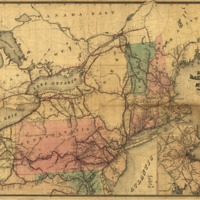
J. Sage & Sons new & reliable rail road map, travellers edition, Eastern.
Dublin Core
Title
J. Sage & Sons new & reliable rail road map, travellers edition, Eastern.
Subject
- Railroads--Middle Atlantic States--Maps
- Railroads--New England--Maps
- United States--Middle Atlantic States
- United States--New England
- Railroads--New England--Maps
- United States--Middle Atlantic States
- United States--New England
Description
Map of the northeastern United States indicating stations along the completed railroad lines.
Creator
Sage (J.) & Sons.
Source
Library of Congress
Publisher
Buffalo, N.Y., 1859.
Date
1859
Format
col. map 42 x 58 cm.
Collection
Citation
Sage (J.) & Sons. , “J. Sage & Sons new & reliable rail road map, travellers edition, Eastern.,” Early American History in Maps, accessed September 26, 2024, https://cornellcolab.net/EarlyAmericanMaps/items/show/191.
